
Kokoda Track Map – Visual Guide of the Kokoda Trail in Papua New Guinea
Introduction
Welcome to the immersive experience of trekking the historic Kokoda Track in Papua New Guinea. This visual guide aims to provide you with a detailed overview of the Kokoda Trail, blending adventure with historical significance. Lace up your boots, and let’s embark on a journey through the heart of Australian wartime history.
The Kokoda Track: An Overview
The Kokoda Track, synonymous with courage and resilience, is a 96-kilometer trail that winds its way through the Owen Stanley Range in Papua New Guinea. The trail gained prominence during World War II as the stage for a crucial campaign that played a pivotal role in the defence of Australia.
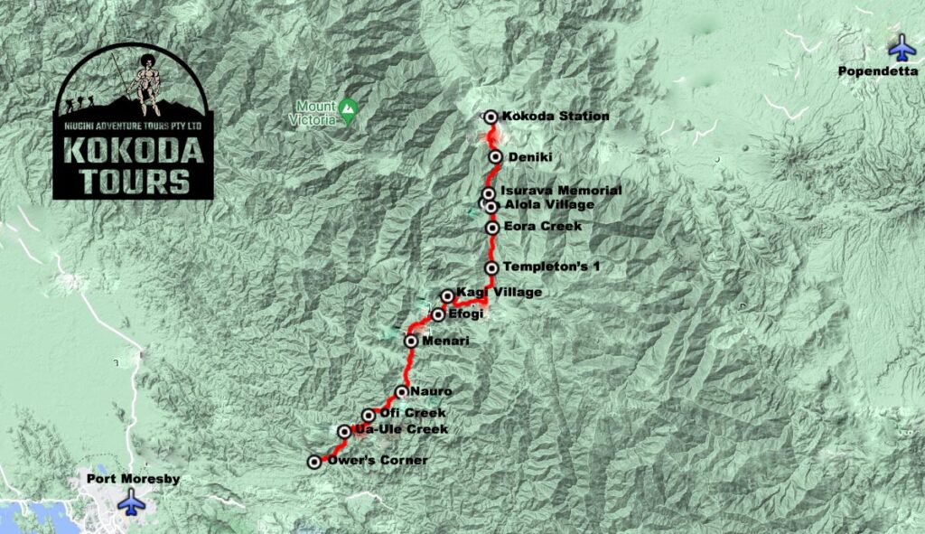
Kokoda Trail Map: Navigating the Historic Path
Topography and Elevation Profile
Understanding the topography of the Kokoda Trail is essential for any trekker. The terrain is marked by steep slopes, dense jungles, and river crossings. The elevation profile, a crucial detail for hikers, highlights the challenging ascents and descents along the trail.
Key Locations Along the Kokoda Track
As you trek from Owers’ Corner to Kokoda, you’ll encounter significant locations that echo with history. These include villages, mountain stations, and the iconic Isurava Battlefield. The trail is not just a physical journey; it’s a cultural and historical odyssey.
Connecting with History: WWII Campaign
The Australian Connection
The Kokoda Trail is intrinsically linked to Australia’s wartime history. It was the site of a critical campaign in 1942, where Australian forces, along with allies, defended against the Japanese invasion. The trail’s significance lies not only in its natural beauty but in the valorous efforts of the people who fought along its rugged path.
Aboriginal and Torres Strait Islander Peoples
Acknowledging the cultural significance of the trail, it’s essential to recognize the contributions of Aboriginal and Torres Strait Islander peoples to the wartime efforts. Their involvement and sacrifices are integral to the Kokoda story.
The Kokoda Trail Today: 2023 Expedition
Adventure Awaits
In 2023, the Kokoda Trail beckons adventurers seeking a blend of physical challenge and historical exploration. This expedition promises a unique opportunity to follow in the footsteps of heroes and gain a profound understanding of the campaign’s impact.
Trekking Details and Practical Information
For a successful trek, it’s crucial to be well-prepared. The Department of Veterans provides valuable resources, including detailed maps and trekking information. Familiarize yourself with the trail map, trekking routes, and essential details to make the most of your Kokoda adventure.
Interactive Elements: Kokoda Trail Map
Elevation Profile Map
The elevation profile map offers a visual representation of the trail’s ups and downs. This detailed depiction will help you mentally prepare for the challenging sections and savor the rewarding descents.
Profile Map with Images
Explore a profile map that not only outlines the geographical features but also contains images capturing the essence of the Kokoda Trail. Immerse yourself in the visual narrative of this historic trek.
ANZAC Portal and Historical Wall
Visit the ANZAC Portal and Historical Wall along the Kokoda Trail. These landmarks are dedicated to preserving the memory of the brave soldiers who fought here. The wall, adorned with names, serves as a poignant reminder of the sacrifices made.
Conclusion
Embarking on the Kokoda Trail is more than a hike; it’s an odyssey through history. The trail’s map is not just a guide; it’s a testament to the resilience of those who traversed it during wartime. As you trek along the Kokoda Track, be aware of the voices echoing through time, and value the feedback of history, for it is through this lens that you truly appreciate the significance of this remarkable expedition.


